Introduction
When it comes to understanding geographical features, a physical map is an important tool. These maps allow us to visualize the landforms and natural features of the earth’s surface. Not only do physical maps serve as essential educational resources, but they are also important for scientific research and environmental analysis. In this article, we will explore the definition, types, and significance of physical maps.
Definition and Characteristics
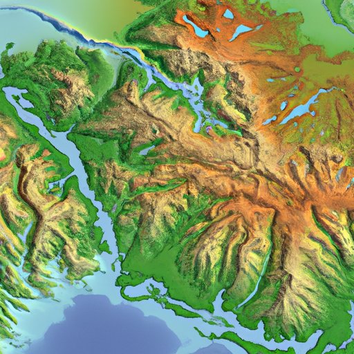
A physical map is a type of map that illustrates the natural features of the earth’s surface, such as mountains, oceans, rivers, and other physical features. Unlike political maps, physical maps do not show state and national boundaries or city locations. Instead, they show the physical features of the land and bodies of water and their relative locations. Physical maps are usually color-coded to indicate elevation, terrain, or climate zones.
One of the primary characteristics of a physical map is that it shows the three-dimensional surface of the earth in a two-dimensional way. This means that the map represents the land features and elevation with contour lines, colors, or shading. Physical maps typically use topographical signifiers, such as contour lines, to show the height and shape of mountain ranges and other geographical features.
Purpose and Benefits
Physical maps are essential tools for scientific research and environmental analysis. Scientists use physical maps to study the topography and geology of an area, which can provide insights into plate tectonics, erosion, and mineral deposits. Additionally, physical maps can help in analyzing and predicting natural disasters. For example, physical maps can show areas that are prone to landslides or earthquakes.
Physical maps are also crucial educational resources. They can help students and researchers visualize the earth’s surface and better understand geographical concepts. By studying different types of physical maps, students can gain a better understanding of the earth’s landforms, ecosystems, and natural resources.
Types of Physical Maps
There are several types of physical maps, and each type serves a unique purpose. Some of the most common types of physical maps include:
Topographical maps
Topographical maps are one of the most common types of physical maps. These maps show the elevation and relief of an area, usually through the use of contour lines. Topographical maps also indicate the location of water features and landforms such as mountains, valleys, and plateaus.
Relief maps
Relief maps are three-dimensional maps that show the contours of the land surface. They are often used for educational or display purposes, and they provide a realistic visualization of the terrain.
Climate maps
Climate maps show the different climate zones of an area, which can be useful for environmental studies. These maps use color-coding to indicate different climate zones, such as temperate, arid, or tropical.
Other types of physical maps
Other types of physical maps include maps that show vegetation patterns, ocean floor features, and earthquake zones. Each type of physical map offers unique information on an aspect of the earth’s surface.
Elements of a Physical Map
Physical maps include several key elements that are used to represent the earth’s physical features. These elements include:
Natural features
Natural features such as mountains, valleys, rivers, and lakes are shown on physical maps. They are usually represented with different colors or shading to indicate their elevation or depth.
Topography
Topography refers to the shape and relief of the land surface. Physical maps use contour lines to show the elevation of mountains and other landforms.
Vegetation
Vegetation patterns are often included on physical maps to show the different types of plants and ecosystems in an area.
Waterways
Physical maps show the location and flow of different bodies of water, such as rivers, oceans, and lakes.
Other elements
Other elements found on physical maps might include elevation markers, scale bars, and legends that explain the colors and symbols used on the map.
Differences between Physical Maps and Other Map Types
While physical maps are essential tools for understanding the earth’s physical features, they differ from other types of maps in several ways. Here are a few comparisons between physical maps and other map types:
Comparison between physical maps and political maps
Political maps show political boundaries, such as state and national borders and city locations. They do not show the physical features of the land, such as mountains or rivers.
Comparison between physical maps and thematic maps
Thematic maps show a specific theme or topic, such as population density or temperature. They do not necessarily show the physical features of an area.
Comparison between physical maps and road maps
Road maps are designed to help drivers navigate roadways and show the location of highways, roads, and cities. They do not show the physical features of the land, such as rivers or mountains.
Historical Significance of Physical Maps
Physical maps have played an essential role in human history. For thousands of years, people have used maps to navigate, explore, and conquer new territories. Early physical maps were often handwritten and illustrated with images of animals and plants.
In the 19th and 20th centuries, physical maps became increasingly important for scientific research. Explorers and scientists used physical maps to study new territories and document landforms and natural resources. Today, physical maps continue to play a vital role in scientific research and education.
Future of Physical Maps
The field of cartography, or mapmaking, is continually evolving. With advances in technology, physical maps are becoming more accurate, detailed, and accessible. Satellite imagery and digital mapping tools have revolutionized the way physical maps are created and used.
However, there are still challenges to be addressed in modern-day cartography. For example, it is challenging to keep physical maps up-to-date in rapidly changing environments. Climate change and urban development are continually altering the earth’s physical features.
Despite these challenges, physical maps will continue to be essential tools for understanding the earth’s physical features and for scientific research and education.
Conclusion
Physical maps are important tools for understanding the earth’s surface and the physical features that shape it. They offer valuable insights into our natural environment and are crucial for scientific research and education. By exploring the different types of physical maps and their elements, we can better understand the world around us and appreciate its complexity.